CAMPO, TTI Use Pedestrian/Bicycle Counts to Improve Transportation Network

The Live Music Capital of the World has one more thing to sing about — its pedestrian and bicycle pathways.
The Austin area is committed to environmental protection and has made great strides in incorporating pedestrian and bicycle traffic into its transportation plans. Travelers using nonmotorized means enjoy scenic paths throughout the area — created with utility and safety in mind, in addition to their visual charms. Though patrons of these pathways see the effort’s success, it can be hard to quantify. Enter the Texas Transportation Institute (TTI).
TTI assisted the Capital Area Metropolitan Planning Organization (CAMPO) in examining pedestrian and bicycle pathways. To see if a transportation improvement has actually had a positive effect, you first need baseline data — how many pedestrians and bicyclists used the path before the improvement? After the improvement, you gather data again — has the improvement drawn more users, and was the benefit worth the cost? Figuring out how to gather this information was the job of TTI researchers.
“We gathered data at 15 locations in the Austin area,” says Joan Hudson, TTI associate research engineer. “Using TTI and City of Austin cameras, we took video counts of traffic using the pathways.”
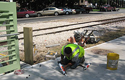
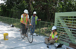
Video counts of traffic, which entail a person watching the video and counting each user, is labor intensive, so the research team also tested and evaluated new equipment for automated traffic counts. Based on these tests, CAMPO purchased two permanent counters and installed them in downtown Austin, allowing for ongoing data collection and analysis.
“We need at least one year of data to begin to identify possible use trends, which include seasonal variations and how traffic fluctuates over the day, week, etc.,” says Hudson. “The permanent counters will give CAMPO important baseline data on how people are using the route and will let the agency forecast future use.”

CAMPO also purchased portable counting equipment for use in evaluating areas for prospective improvements, such as adding a shoulder or bike lane to a roadway. Information from counters allows the agency to compare different improvement projects, in addition to later evaluating the success of the project through comparison of before-and-after data. TTI also developed tools to identify missing links in the pedestrian/bicycle network and to forecast usage.
“The forecasting method TTI developed allows us to evaluate projects and their impact on the transportation system,” says Greg Griffin, senior planner with CAMPO. “With the tools TTI has provided, we can get objective data about demand that we can use in combination with public involvement for long-range planning. This is the first step in equalizing the transportation modes.”
