What's the Problem?
Currently, U.S. Customs and Border Protection (CBP) publishes the number of lanes open at the land ports of entry (LPOEs) on their website. This information is updated once every hour in most cases. However, it has been observed that in some cases this information is not updated for several hours, and in other cases, the information has proven unreliable. Knowing whether or not a lane is open or closed at the border is important because it:
- Allows passenger and freight carriers to make an informed decision about departure times, mode choice and bridge selection.
- Enables better mobility analysis for the LPOEs.
- Enables modelers to reliably calibrate models for LPOEs.
- Develops better short-term bridge crossing time estimation algorithms.
What's the Solution?
Research was needed to identify and test sensors or methodologies to remotely determine whether lanes are open or closed. One of the options for monitoring lanes involves a detector that was evaluated in previous Center for International Intelligent Transportation Research (CIITR) research—the LeddarTech IS16 LED scanner. Earlier findings indicated that its count accuracy was excellent for counting either passenger or commercial vehicles. However, its typical mounting requirement places it directly over lanes pointing downward. Since accurate lane counts would also meet the needs of this project, the LeddarTech in its “normal” orientation was one solution considered for determining which lanes are open.
A secondary aspect of the project was to find a sensor or methodology that could be more “remote” or at a greater distance from the lanes being monitored. Therefore, researchers chose two detection systems that could be mounted away from the targeted lanes:
- The LeddarTech IS16 LED Scanner System placed in a less typical orientation—sidefire facing the side of passing vehicles.
- The SmartSensor Matrix—a radar detector from Wavetronix—along with its companion Click 650.
How Was the Study Done?

The Texas A&M Transportation Institute began to assemble the components needed to install and test the two systems. Limited testing occurred at the Texas A&M University RELLIS Campus using a portable trailer to mount the detector components. Upon successful testing and increased confidence that the two detectors would adequately meet the project objectives, researchers planned a full-blown test in El Paso.
The plan for installing the proposed detectors and the work necessary at the Zaragoza southbound passenger site was as follows:
- Install Wavetronix Matrix and Click 650.
- Install LeddarTech IS16 oriented in sidefire mode to cover the first two to three lanes.
- Set up trailer-mounted camera to monitor all seven lanes and record video as ground truth.
- Connect cables from each sensor and the camera to trailer connections.
Following connection on-site, the field crew did the following:

- Terminated wiring from both sensors.
- Installed phone modem.
- Installed computer loaded with appropriate software.
- Connected power to all installed systems.
- Checked all systems for proper operation.
- Troubleshot any problems as required.
- Collected field data.
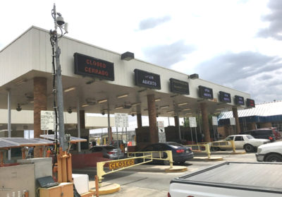
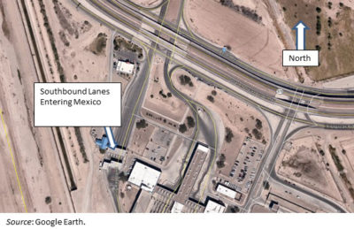
Figure 1 shows the location of the trailer in relation to the seven lanes operated at the toll facility. Figure 2 shows an aerial view of the southbound toll lanes for passenger cars used for this research.
Findings
The results of the Matrix vehicle counts for July 21, 2017, compared to recorded video and City of El Paso counts indicate significant differences in hourly numerical values. However, based on these data, the Matrix would provide adequate lane status (open or closed) for the four or five lanes nearest the detector.
For the LeddarTech, preliminary results (based mostly on observation) indicate the detector could probably determine lane status for as many as three lanes at the height and offset it was mounted for these tests. It could probably count additional lanes if mounted higher than 17 ft. To be effective as a long-term solution for determining lane status, however, it would need to have software developed to count and store traffic data based on specified heights and offsets.
Recommended Next Steps
Both detectors tested in this research are potential solutions for providing lane status. However, decision-makers should consider that mounting a detector over each lane (e.g., the LeddarTech IS16) could provide both vehicle counts and lane status. That solution would defy the objective of being remote, but it would generate accurate counts. In some cases, a simpler solution might also meet this need, such as:
- Where overhead electronic signs are used, connect to the sign wiring to determine lane status.
- Where gates are used, use electrical contacts at the closure point.
- Where gates are used, install a device (e.g., compass) to monitor the direction (azimuth) of the gate.
Since this research was the first attempt to deploy the LeddarTech IS16 off the lanes, more research is needed to develop guidelines on how it should be positioned to optimize performance. Also, the additional tests might also evaluate the other option cited in this study—to position it to view license plates to exploit their brighter reflective surface instead of a sidefire orientation.
Project Title
Remotely Determine Lane Status at Border Land Ports of EntryProject Number
185917-00010
Project Sponsor(s)
Center for International Intelligent Transportation Research
Project Categories
Freight Movement, Mobility
Project Termination Date
August 2017
Project Publications
For More Information
Dan Middleton, Ph.D., PE
Research EngineerSystem Reliability Division
Texas A&M Transportation Institute
Texas A&M University System
2929 Research Parkway
College Station, TX 77843
Ph. (979) 317-2826 Ext. 42826
[email protected]