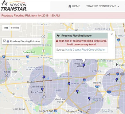
Houston residents often experience heavy rainfall events that make travel more difficult and even dangerous. In collaboration with Houston TranStar, the Texas A&M Transportation Institute (TTI) developed a real-time flood-warning tool to educate motorists on high-risk flood areas during severe storms. Houston TranStar’s website and traffic map, seen by over three million unique visitors during Hurricane Harvey, informs travelers as they determine routes through the Houston region. | Learn more about the Houston TranStar flood-warning system.
This past year, TTI and Houston TranStar won an Intelligent Transportation Society of Texas Award for the flood-warning system. The project also received the Texas Public Works Association’s Technical Innovation Award and, along with the Harris County Flood Control District (HCFCD), a Technology Award at the Emergency Management Association of Texas’s Symposium.
The National Operations Center of Excellence (NOCoE) recently announced the winners of the 2nd annual NOCoE Transportation Systems Management and Operations (TSMO) Awards. Out of 46 entries for the awards, NOCoE chose Houston TranStar’s flood-warning technology as the winner in the “Best TSMO Project” category. The award recognizes TSMO projects, in response to a specific event, that use innovative practices to save lives, time and money. TSMO award winners will be recognized at the American Association of State Highway and Transportation Officials Spring Meeting May 26–29, 2020, in Kansas City, Missouri.
“Hurricane Harvey remains fresh in Houston’s memory, and the world’s not likely to forget the photos and videos shared of residents climbing into boats on vast bodies of water,” notes Mike Vickich, TTI senior systems analyst. “With this TSMO project, Houston TranStar met a need for safety information during these types of situations. The flood-warning system has evolved into a critical resource for governments and other entities to put safety measures in place for the public.”
The roadway flood-warning system is the result of a collaborative effort by TTI, Houston TranStar, HCFCD and the Texas Department of Transportation. The tool combines rainfall and stream elevation data with real-time traffic information to show areas with a high likelihood of roadway flooding. Travelers can avoid these areas where there might be water in the road and plan out alternate routes through the region.
“Our project enhances traveler safety in the Greater Houston region by giving motorists reliable information to avoid roadways that are highly likely to be flooded,” explains Dinah Massie, Houston TranStar executive director.